A ZIP Code is a fundamental element of the United States Postal Service (USPS) system, designed to streamline and expedite mail delivery across the nation. It’s a five-digit numeric code that pinpoints specific geographic locations, ensuring your letters and packages reach their intended destinations efficiently. But what exactly does a ZIP Code represent, and how does it work? Let’s delve into the details of this crucial addressing component.
Decoding the ZIP Code Structure
The five digits of a ZIP Code are not randomly assigned; they follow a structured system that reflects the geographic organization of the United States. Each digit plays a role in narrowing down the location, starting from the broadest region to more specific delivery areas.
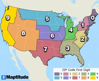
The First Digit: National Areas
The very first digit of a ZIP Code divides the United States into ten large geographical areas, ranging from 0 in the Northeast to 9 in the West. This initial digit provides a broad regional classification, helping to direct mail to the correct part of the country.
The Second and Third Digits: Regional and Metro Areas
Moving to the second and third digits, the ZIP Code becomes more specific. These digits designate a particular region within the larger area defined by the first digit. They can represent a state, a heavily populated area within a state, or even a combination of less populated states. These digits further refine the mail’s route, guiding it towards major metropolitan areas or postal processing centers.
The Last Two Digits: Delivery Areas
The final two digits of the five-digit ZIP Code pinpoint specific delivery areas within the regions defined by the first three digits. These last digits can represent a cluster of addresses, a specific post office, or even a particular city or town. They ensure that mail is sorted down to the local level for final delivery.
ZIP Codes as Areas and Points
While often visualized as geographic areas, it’s important to understand that the USPS primarily uses ZIP Codes as delivery routes rather than defined boundaries. However, for mapping and data analysis purposes, ZIP Codes are often represented in two ways: as areas and as points.
ZIP Code Areas: Approximate Boundaries
Many ZIP Codes, especially those covering residential and business addresses, can be approximated as geographic areas. These area boundaries are created by grouping smaller census blocks based on the dominant ZIP Code within those blocks. This provides a visual representation of where addresses within a particular ZIP Code are generally located. Mapping software like Maptitude uses sophisticated techniques to create accurate ZIP Code area boundaries for geographic analysis.
ZIP Code Points: For Specific Locations
Not all ZIP Codes are best represented as areas. Some, particularly those for individual businesses, buildings, or Post Office Boxes (PO Boxes), are better represented as points. These points are typically located at the main post office serving the ZIP Code or a central location within the designated delivery zone. Point representation is useful for ZIP Codes that don’t have a broad geographic distribution.
Expanding ZIP Codes: ZIP+4 and Carrier Routes
To further enhance mail sorting and delivery precision, the USPS utilizes ZIP+4 codes and carrier routes, which build upon the basic five-digit ZIP Code.
ZIP+4: Enhanced Precision
The ZIP+4 code is an extension of the standard ZIP Code, adding a hyphen and four extra digits to the original five. These additional digits pinpoint a more specific delivery location, such as a particular building, a floor within a building, or even a side of a street. ZIP+4 codes significantly improve sorting accuracy, especially for businesses and large residential complexes.
Carrier Routes: Optimizing Delivery
Within each ZIP Code, the USPS organizes addresses into carrier routes. A carrier route is a designated path for a mail carrier, encompassing a group of addresses in close proximity. Each carrier route is identified by the 5-digit ZIP Code followed by a letter and three numbers. Carrier routes streamline the daily delivery process, ensuring efficient and organized mail distribution within neighborhoods and communities.
PO Boxes and ZIP Codes
PO Boxes, located at post offices, also have associated ZIP Codes. These ZIP Codes are often represented as points on maps, frequently clustered together at the post office location. PO Boxes provide a secure and convenient way to receive mail, particularly for individuals or businesses without a fixed physical address.
The Role of ZIP Codes in Mapping and Data Analysis
Beyond mail delivery, ZIP Codes are invaluable for geographic analysis and data organization. Mapping software utilizes ZIP Code data to visualize demographic information, sales territories, customer distributions, and much more. Businesses leverage ZIP Codes to understand geographic patterns, target marketing efforts, and make informed decisions based on location-based data. Aggregating data by ZIP Code allows for insightful analysis of geographic trends and variations.
Conclusion
In summary, a ZIP Code is more than just a five-digit number; it’s a cornerstone of the US postal system, a geographic identifier, and a valuable tool for data analysis. Understanding the structure and different representations of ZIP Codes provides a deeper appreciation for the intricate system that ensures mail reaches its destination efficiently across the United States. From directing mail across vast regions to enabling detailed geographic data analysis, ZIP Codes play a vital role in both logistics and information management.