Summer in regions like the Ohio Valley brings not only heat and humidity but also the risk of severe weather phenomena, including a powerful and sometimes underestimated event known as a derecho. Understanding derechos is crucial for residents in susceptible areas to prepare for and mitigate potential damage.
A derecho (pronounced “deh-REY-cho”) is defined as a widespread, long-lasting straight-line wind storm associated with a band of rapidly moving showers or thunderstorms. While the destructive power of a derecho can rival that of a tornado, the key difference lies in the direction of the damage. Derechos inflict damage in a linear fashion, hence the term “straight-line wind damage” often used to describe their impact.
To officially be classified as a derecho, the wind damage swath must extend for more than 240 miles (approximately 400 kilometers). Furthermore, within this swath, wind gusts must reach at least 58 mph (93 km/h) or greater across most of its length. These criteria highlight the extensive reach and intensity of these storm systems.
Derecho Formation: Bow Echoes and the Gust Front Connection
The development of a derecho is intrinsically linked to the formation of bow echoes within thunderstorms. A bow echo, a radar signature resembling an archer’s bow, typically originates from a cluster of thunderstorms but can also evolve from a single, potent storm. These formations are most common when atmospheric winds are strong and unidirectional, meaning they maintain a consistent direction with increasing altitude but gain speed.
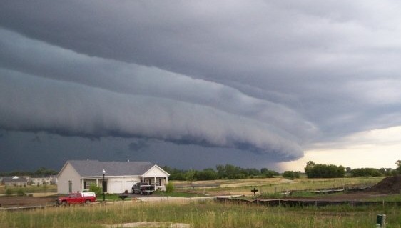
As a thunderstorm’s rain-cooled downdraft descends and hits the Earth’s surface, it spreads horizontally, accelerating most rapidly in the direction of the prevailing atmospheric flow. This outward surge of cool, dense air forces the surrounding warmer, moist air upwards along the leading edge of the outflow, known as the gust front. Gust fronts are often visually marked by ominous, low-hanging clouds called “arcus clouds,” as seen in the image above.
Stages of Derecho Development
Derecho formation is a multi-stage process, intensifying over time as atmospheric conditions align.
- Initial Bow Echo Formation: As described above, the process begins with thunderstorm development and the formation of a gust front driven by rain-cooled air.
- Intensification and Steady State: The rainfall from newly developed storms further cools the air, strengthening the cold pool. This, in turn, enhances the inflow of air from the rear of the storm complex and encourages the downward transfer of high-momentum winds from upper atmospheric levels. These processes can lead to a near steady-state condition, allowing the storm system to persist and travel vast distances rapidly. At this stage, the storm system typically exhibits a pronounced bow shape on radar.
- Continued Acceleration and Widespread Damage: As thunderstorm coverage expands, the reinforcing effect of rain-cooled air on the cold pool intensifies. The line of storms continues to accelerate, either as a single large bow echo or as multiple smaller bow echoes within a larger line. This phase is characterized by prolonged periods of widespread and persistent wind damage across a large area.
Types of Derechos: Progressive vs. Serial
Derechos are broadly categorized into two main types: progressive derechos and serial derechos, each with distinct characteristics and formation mechanisms.
Progressive Derechos: These derechos are associated with very unstable, hot, and humid environments coupled with strong upper-level winds. They often develop on the periphery of strong high-pressure systems aloft, where hot, humid surface conditions overlap with stronger winds at higher altitudes. This specific atmospheric setup makes progressive derechos more challenging to forecast. The “cap,” a layer of warmer air in the mid-levels of the atmosphere associated with high-pressure systems, can inhibit initial thunderstorm development. Triggers like subtle disturbances in upper-level flow or surface convergence from frontal boundaries are often necessary to initiate these storms, making their prediction difficult. The devastating June 29, 2012 derecho, which impacted millions from the upper Midwest to the Atlantic coast, originated from a subtle upper-level disturbance, highlighting the rapid and sometimes unexpected development of progressive derechos.
Serial Derechos: Serial derechos, in contrast, form along lines oriented more parallel to the mid-level wind flow. This results in longer lines of storms that travel shorter distances compared to progressive derechos. The wind profile associated with serial derechos exhibits greater directional shear (winds changing direction with height), leading to the formation of multiple smaller bow echoes and an increased risk of brief, tornado-like spin-ups. Serial derechos are generally easier to forecast because they are often associated with larger-scale weather systems that are more readily predictable.
Derecho Climatology in the United States
Derechos are most frequent in the United States across two primary corridors: the “Corn Belt,” extending from the upper Mississippi Valley southeast into the Ohio Valley, and another from the southern Plains northeast into the mid-Mississippi Valley.
During the cooler months (September to April), derechos are less common but are most likely to occur from east Texas into the southeastern states. While rare west of the Great Plains, isolated derechos have been observed in the interior western US, especially during spring and early summer.
The vast majority of derechos – approximately 70% – occur during the warm season months of May through August. The remaining 30% occur during the cooler season, demonstrating the strong link between derecho formation and warm weather conditions.
The Power of a Derecho: The June 29, 2012 Example
The June 29, 2012 derecho serves as a stark reminder of the destructive potential of these storms. This event swept from the upper Midwest to the central Atlantic coast in mere hours, leaving behind a trail of damage. Nearly 1,200 reports of damaging winds were documented, with numerous instances of hurricane-force gusts (74 mph or greater). The powerful winds extended far offshore into the Atlantic Ocean, highlighting the immense scale and intensity of this derecho.
Staying Safe During a Derecho
Derechos are significant weather hazards capable of causing widespread damage and disruption. Understanding what derechos are, how they form, and when and where they are most likely to occur is the first step in preparedness. Staying informed through weather forecasts and warnings, and taking appropriate safety measures when a derecho threatens, are crucial for minimizing risk and ensuring safety.
For deeper information and acknowledgements, please visit the Storm Prediction Center’s About Derechos page.