GPS, or Global Positioning System, is now an indispensable tool in modern life. Have you ever wondered what it is and how it works? This comprehensive guide from WHAT.EDU.VN explores the depths of GPS technology, uncovering its definition, applications, and benefits. Discover the location technology that powers navigation, tracking, and timing across the globe. Learn about the underlying systems and explore how GPS is enhancing various industries, making life more efficient. Delve deeper to understand positioning, navigation, and satellite technology.
1. Defining GPS: What Is Global Positioning System?
GPS stands for Global Positioning System. It’s a satellite-based radionavigation system owned by the United States government and operated by the United States Space Force. One of the global navigation satellite systems (GNSS) that provides geolocation and time information to a GPS receiver anywhere on or near the Earth where there is an unobstructed line of sight to four or more GPS satellites. WHAT.EDU.VN can help you understand complex technologies; simply ask us any question and get a free answer.
1.1. Core Functionality of GPS
At its core, GPS serves three primary functions:
- Positioning: Determining the precise location of a device or user.
- Navigation: Guiding users from one location to another.
- Timing: Providing highly accurate time measurements.
.png)
Illustration of satellite ranging, showing how GPS uses signals from multiple satellites to pinpoint a location.
1.2. The Technical Definition of GPS
The Global Positioning System (GPS) is a satellite-based navigation system that utilizes a network of at least 24 satellites orbiting Earth. These satellites transmit precise microwave signals that are received by GPS devices on the ground, in the air, and at sea. By calculating the time it takes for signals from multiple satellites to reach the receiver, the device can accurately determine its location, speed, and direction. This process, called trilateration, is essential to the functionality of GPS. WHAT.EDU.VN provides easy-to-understand explanations for everyone; ask us any technical question today.
2. How Does GPS Work?
GPS technology relies on a complex interaction between satellites, ground control stations, and user devices. Here’s a detailed breakdown of the process:
2.1. The Space Segment: GPS Satellites
The GPS constellation consists of at least 24 active satellites orbiting Earth at an altitude of approximately 20,200 kilometers (12,600 miles). These satellites are strategically positioned to ensure that at least four satellites are visible from virtually any point on the globe at any given time. Each satellite transmits continuous radio signals containing information about its position and the time the signal was transmitted. The satellites circle the Earth twice a day and each satellite sends a unique signal, orbital parameters, and time. WHAT.EDU.VN simplifies science; ask us any question you might have.
2.2. The Control Segment: Ground Stations
The Control Segment comprises a network of ground-based monitoring stations, master control stations, and ground antennas. These stations track the satellites, monitor their signals, and ensure their proper functioning. They also make corrections to satellite orbits and clock errors to maintain the accuracy of the GPS system. There are monitoring stations on almost every continent in the world, including North and South America, Africa, Europe, Asia, and Australia.
2.3. The User Segment: GPS Receivers
The User Segment includes all GPS receivers, from smartphones and car navigation systems to specialized devices used in surveying, aviation, and maritime applications. These receivers pick up signals from GPS satellites and use the information to calculate their position, velocity, and time. To calculate location, a GPS device must be able to read the signal from at least four satellites.
2.4. Trilateration: Pinpointing Location
GPS receivers use a technique called trilateration to determine their precise location. Here’s how it works:
- Signal Reception: The GPS receiver picks up signals from at least four satellites.
- Distance Calculation: The receiver calculates the distance to each satellite based on the time it takes for the signal to arrive.
- Position Determination: Using the distances to the satellites, the receiver determines its position by finding the intersection of multiple spheres.
Since a GPS device only gives information about the distance from a satellite, a single satellite cannot provide much location information. Satellites do not give off information about angles, so the location of a GPS device could be anywhere on a sphere’s surface area.
When a satellite sends a signal, it creates a circle with a radius measured from the GPS device to the satellite.
When we add a second satellite, it creates a second circle, and the location is narrowed down to one of two points where the circles intersect.
With a third satellite, the device’s location can finally be determined, as the device is at the intersection of all three circles.
That said, we live in a three-dimensional world, which means that each satellite produces a sphere, not a circle. The intersection of three spheres produces two points of intersection, so the point nearest Earth is chosen.
2.5. Accuracy Factors in GPS
Several factors can affect the accuracy of GPS, including:
- Atmospheric Conditions: Ionospheric and tropospheric delays can distort GPS signals.
- Satellite Geometry: The position of the satellites relative to the receiver can impact accuracy.
- Obstructions: Physical obstructions such as buildings, trees, and mountains can block or reflect GPS signals.
- Receiver Quality: The quality of the GPS receiver itself can affect its ability to accurately process signals.
3. The Three Segments of GPS Technology
GPS technology is organized into three primary segments, each essential to the system’s operation: the Space Segment, the Control Segment, and the User Segment.
3.1. Space Segment: Satellites in Orbit
The Space Segment is comprised of the GPS satellites orbiting Earth. These satellites transmit the signals that GPS receivers use to calculate their position.
3.2. Ground Control Segment: Monitoring and Management
The Ground Control Segment includes the ground stations that monitor and manage the GPS satellites. These stations track the satellites, upload commands, and perform maintenance. Control activities include tracking and operating the satellites in space and monitoring transmissions.
3.3. User Equipment Segment: Receivers and Transmitters
The User Equipment Segment consists of the GPS receivers and transmitters used by individuals and organizations. This includes smartphones, car navigation systems, and specialized GPS devices.
4. Key Uses of GPS Technology
GPS technology is used in a wide range of applications, impacting numerous industries and aspects of daily life.
4.1. Navigation: Guiding Travel
One of the most well-known uses of GPS is navigation. GPS is used in car navigation systems, smartphone apps, and aviation and maritime navigation to guide people and vehicles from one location to another.
4.2. Location: Determining Positions
GPS is used to determine the precise location of people, objects, and places. This is essential for various applications, including mapping, surveying, and asset tracking.
4.3. Tracking: Monitoring Movement
GPS is used to track the movement of vehicles, people, and assets. This is important for logistics, transportation, and security applications.
4.4. Mapping: Creating Detailed Charts
GPS is used to create accurate maps of the world. Surveyors, scientists, pilots, boat captains, first responders, and workers in mining and agriculture, are just some of the people who use GPS on a daily basis for work. They use GPS information for preparing accurate surveys and maps, taking precise time measurements, tracking position or location, and for navigation.
4.5. Timing: Precise Synchronization
GPS provides precise timing information that is used in various applications, including telecommunications, finance, and scientific research. GPS works at all times and in almost all weather conditions.
5. Real-World Applications of GPS
The applications of GPS technology are diverse and continuously expanding. Here are some notable examples:
5.1. Transportation and Logistics
- Fleet Management: GPS tracking helps companies monitor and manage their vehicle fleets, optimizing routes and improving efficiency.
- Delivery Services: GPS navigation ensures accurate and timely deliveries.
- Autonomous Vehicles: GPS is a critical component of self-driving cars and trucks.
Illustration of a helicopter, representing the use of GPS in aviation and emergency services.
5.2. Emergency Services
- Search and Rescue: GPS helps locate individuals in distress, improving the effectiveness of search and rescue operations.
- Emergency Response: GPS navigation guides emergency responders to incident locations quickly and efficiently.
5.3. Agriculture
- Precision Farming: GPS-guided equipment enables farmers to optimize planting, fertilizing, and harvesting processes.
- Livestock Tracking: GPS collars allow ranchers to monitor the location and movement of their livestock.
5.4. Surveying and Mapping
- Land Surveying: GPS is used to create accurate surveys of land boundaries and topography.
- Geographic Information Systems (GIS): GPS data is integrated into GIS to create detailed maps and spatial analysis tools.
5.5. Recreation and Fitness
- Hiking and Backpacking: GPS devices help hikers and backpackers navigate trails and track their progress.
- Fitness Tracking: GPS-enabled wearables monitor distance, speed, and route during workouts.
6. Accuracy of GPS Devices Explained
GPS device accuracy depends on many variables, such as the number of satellites available, the ionosphere, the urban environment, and more. While GPS is generally very accurate, several factors can affect its precision:
6.1. Factors Influencing Accuracy
- Atmospheric Conditions: The ionosphere and troposphere can cause delays and distortions in GPS signals.
- Satellite Geometry: The arrangement of satellites in the sky can affect accuracy.
- Signal Obstructions: Buildings, trees, and terrain can block or reflect GPS signals, leading to errors.
- Receiver Quality: The quality of the GPS receiver and its ability to process signals can impact accuracy.
6.2. Common Sources of Error
- Ionospheric and Tropospheric Delays: These atmospheric effects can slow down GPS signals, causing position errors.
- Multipath Errors: Signals reflected off surfaces can interfere with direct signals, leading to inaccurate measurements.
- Receiver Clock Errors: Inaccuracies in the receiver’s internal clock can affect the timing of signal reception.
- Orbital Errors: Slight errors in the satellite’s orbit information can contribute to position errors.
6.3. Improving GPS Accuracy
- Differential GPS (DGPS): Uses fixed ground-based reference stations to correct GPS signals and improve accuracy.
- Assisted GPS (A-GPS): Uses cellular networks to provide initial location information and speed up GPS acquisition.
- Real-Time Kinematic (RTK): Provides centimeter-level accuracy by using carrier phase measurements and reference stations.
7. Brief History of GPS Technology
Humans have been practicing navigation for thousands of years using the sun, moon, stars, and later, the sextant. GPS was an advancement of the 20th century made possible by space-age technology. The development of GPS technology spans several decades, with significant milestones along the way.
7.1. Early Developments
- 1957: The launch of Russia’s Sputnik I satellite in 1957 ushered in the possibility of geolocation capabilities and soon after, the U.S. Department of Defense began using it for submarine navigation.
- 1973: The U.S. Department of Defense initiated the GPS program.
7.2. Key Milestones
- 1978: The first GPS satellite was launched.
- 1983: The U.S. government made GPS publically available, but still kept control of the available data.
- 1995: The GPS constellation achieved full operational capability.
- 2000: Companies and the general public gained full access to the use of GPS, eventually paving the way for greater GPS advancement. Selective Availability (SA), which intentionally degraded GPS accuracy for civilian users, was discontinued.
For more on the history and development of GPS, see our post on the History of GPS satellites and commercial GPS tracking.
8. Understanding GNSS: Global Navigation Satellite Systems
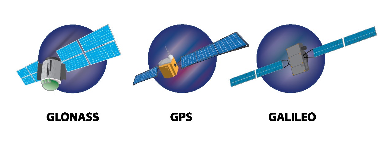
A GPS is considered to be a Global Navigation Satellite System (GNSS) — meaning it is a satellite navigation system with global coverage. GPS is part of a broader category known as Global Navigation Satellite Systems (GNSS).
8.1. Major GNSS Systems
- GPS (United States): The original and most widely used GNSS.
- GLONASS (Russia): Russia’s Global Navigation Satellite System.
- Galileo (European Union): The EU’s GNSS, designed for civilian use.
- BeiDou (China): China’s GNSS, providing global coverage.
8.2. Regional Navigation Satellite Systems
- QZSS (Japan): A regional system primarily serving Japan and the Asia-Pacific region.
- IRNSS (India): A regional system serving India and surrounding areas.
8.3. How GNSS Improves Accuracy
GNSS receivers can utilize signals from multiple satellite systems to improve accuracy and reliability. By combining data from GPS, GLONASS, Galileo, and BeiDou, receivers can achieve better coverage and more precise positioning.
Illustration of GLONASS, GPS and Galileo Satellites, showcasing the diversity of global navigation systems.
9. GPS Devices vs GNSS Devices: What’s the Difference?
Though GPS is a subset of GNSS, receivers are differentiated as GPS (meaning GPS-only) or GNSS. A GPS receiver is only capable of reading information from satellites in the GPS satellite network, while the typical GNSS device can receive information from both GPS and GLONASS (or more than these two systems) at a time. While the terms GPS and GNSS are often used interchangeably, there are important distinctions between GPS-only devices and GNSS devices.
9.1. GPS-Only Devices
GPS-only devices can only receive signals from the GPS satellite constellation. These devices are typically less expensive but may have lower accuracy and reliability in certain environments.
9.2. GNSS Devices
GNSS devices can receive signals from multiple satellite constellations, including GPS, GLONASS, Galileo, and BeiDou. This multi-constellation capability improves accuracy, reliability, and coverage, especially in urban canyons and challenging environments.
9.3. Benefits of GNSS
- Improved Accuracy: Utilizing multiple satellite systems leads to more precise positioning.
- Enhanced Reliability: GNSS receivers can continue to function even if one satellite system is unavailable.
- Better Coverage: GNSS provides better coverage in areas where GPS signals may be obstructed or weak.
9.4. What are GNSS Devices?
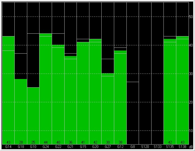
GNSS devices, or Global Navigation Satellite System devices, are electronic devices that use signals from a network of satellites to determine the location, speed, and direction of a person or object.
A GNSS receiver has 60 satellites available for viewing. While a device only needs three satellites to determine its location, accuracy is improved with a larger number of satellites. The chart below shows an example of the number of satellites available (shown in green), along with its signal strength (height of the column), to a GPS receiver. In this case, 12 satellites are available.
Typical GPS-only test board showing 12 satellite signals (green), using U-Center software.
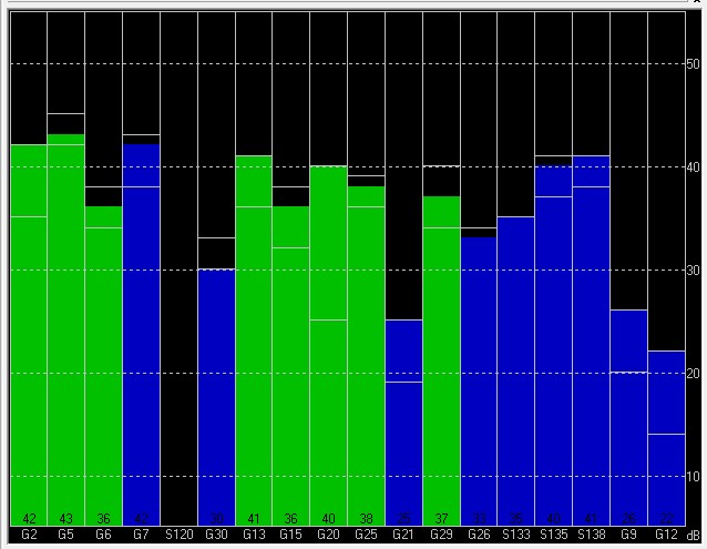
A GNSS device can see more satellites, which helps improve device accuracy. In the chart below, there are 17 available satellites. Green bars are part of GPS and blue bars are part of GLONASS.
Typical GNSS test board showing 17 satellite signals (GPS = green; GLONASS = blue), using U-Center software.
A larger number of satellites providing information to a receiver enables the GPS device to calculate location with greater precision. More satellites give a device a better chance of getting a positional fix when the receiver has calculated the location of the user.
That being said, GNSS receivers have some drawbacks:
- The cost of GNSS chips are higher than those of GPS devices.
- GNSS uses a wider bandwidth (1559-1610 MHz) than GPS (1559-1591 MHz).This means standard GPS radio frequency components, such as antennas, filters, and amplifiers, cannot be used for GNSS receivers, resulting in a greater cost impact.
- Power consumption would be slightly higher than with GPS receivers as it connects to more satellites and runs the calculations to determine location.
10. The Future of GPS Technology
Countries continue to build and make improvements to their GPS systems. Efforts worldwide are being made to increase accuracy and improve reliability and GPS capabilities. The future of GPS and GNSS technology is focused on increasing accuracy, improving reliability, and expanding capabilities.
10.1. Advancements in Accuracy
- Improved Satellite Technology: Next-generation satellites will feature more accurate clocks and stronger signals.
- Enhanced Ground Infrastructure: Upgraded ground stations will provide more precise monitoring and corrections.
- Advanced Algorithms: Sophisticated algorithms will reduce errors caused by atmospheric effects and signal obstructions.
10.2. Increased Reliability
- Redundant Systems: Multiple satellite systems will ensure continuous coverage even if one system fails.
- Interoperability: Seamless integration of different GNSS systems will enhance reliability and performance.
10.3. Expanding Capabilities
- Indoor Positioning: New technologies will enable accurate positioning indoors, where GPS signals are weak or unavailable.
- Autonomous Applications: GPS and GNSS will play a crucial role in the development of autonomous vehicles, drones, and robots.
The future of GPS tracking will likely be far more accurate and effective for both personal and business use.
11. Frequently Asked Questions (FAQs) About GPS
Here are some common questions about GPS, providing quick and informative answers:
| Question | Answer |
|---|---|
| What does GPS stand for? | Global Positioning System. |
| How many satellites are needed for GPS to work? | At least four satellites are needed to determine a precise location. |
| What is trilateration? | A method used by GPS receivers to determine their location by calculating distances from multiple satellites. |
| What is the difference between GPS and GNSS? | GPS is a specific GNSS. GNSS refers to all global navigation satellite systems, including GPS, GLONASS, Galileo, and BeiDou. |
| What factors affect GPS accuracy? | Atmospheric conditions, satellite geometry, signal obstructions, and receiver quality. |
| What are some common applications of GPS? | Navigation, tracking, mapping, surveying, and timing. |
| How can GPS accuracy be improved? | Using Differential GPS (DGPS), Assisted GPS (A-GPS), and Real-Time Kinematic (RTK). |
| What is the future of GPS technology? | Increased accuracy, improved reliability, and expanding capabilities, including indoor positioning and autonomous applications. |
| Is GPS free to use? | Yes, GPS is a free service provided by the U.S. government. However, some applications and devices that use GPS may require a subscription or purchase. |
| Can GPS be used indoors? | GPS signals are typically weak indoors, but new technologies are being developed to enable indoor positioning. |
| How does GPS work in remote areas? | GPS works well in remote areas as long as there is an unobstructed line of sight to the satellites. |
| What security measures are in place for GPS? | GPS signals are encrypted to prevent spoofing and jamming. |
| How does GPS integrate with other technologies? | GPS integrates with cellular networks, Wi-Fi, and other sensors to provide enhanced location services. |
| What are the environmental impacts of GPS? | GPS technology helps reduce fuel consumption and emissions by optimizing routes and improving transportation efficiency. |
| What regulations govern the use of GPS? | The U.S. government oversees the operation and maintenance of the GPS system. |
| What are the limitations of GPS in extreme conditions? | Extreme weather conditions, such as heavy storms or solar flares, can affect GPS accuracy. |
| How is GPS used in scientific research? | GPS is used in various scientific fields, including geology, meteorology, and oceanography, to collect precise location and time data. |
| What are the ethical considerations of GPS tracking? | Privacy concerns related to tracking individuals and the potential for misuse of location data. |
| How does GPS compare to other navigation systems? | GPS is the most widely used GNSS, but other systems like GLONASS, Galileo, and BeiDou offer similar capabilities and can enhance overall performance. |
| What are the educational resources for learning about GPS? | Online courses, tutorials, and academic programs provide in-depth knowledge about GPS technology and its applications. |

12. Unlock Answers to Any Question at WHAT.EDU.VN
Do you have more questions about GPS or any other topic? WHAT.EDU.VN provides a platform where you can ask any question and receive free, accurate answers from a community of experts.
12.1. How WHAT.EDU.VN Can Help
- Free Answers: Get answers to your questions without any cost.
- Expert Community: Connect with knowledgeable individuals who can provide insightful responses.
- Wide Range of Topics: Ask questions about anything, from technology and science to history and culture.
- Easy-to-Use Platform: Our website is designed for simplicity, making it easy to ask questions and find answers.
12.2. Why Choose WHAT.EDU.VN?
- Quick Responses: Receive answers to your questions promptly.
- Accurate Information: Our community strives to provide reliable and factual information.
- Comprehensive Coverage: Explore a vast range of topics and expand your knowledge.
- Community Support: Engage with a supportive community of learners and experts.
Don’t let your questions go unanswered. Visit WHAT.EDU.VN today and experience the power of free knowledge. Our team is dedicated to providing you with the information you need to excel in your studies, career, and personal life.
Contact Us:
- Address: 888 Question City Plaza, Seattle, WA 98101, United States
- WhatsApp: +1 (206) 555-7890
- Website: WHAT.EDU.VN
Ask your questions now and get the answers you need to thrive. At what.edu.vn, we’re committed to making knowledge accessible to everyone. Let us help you unlock your full potential.