Latitude and longitude are fundamental concepts in geography, and at WHAT.EDU.VN, we’re dedicated to providing clear and concise explanations. Latitude and longitude work together as a coordinate system, a geographical coordinate system, to pinpoint any location on Earth’s surface. This article will delve deep into understanding what latitude and longitude are, their significance, how they are measured, and their various applications. This guide offers insights into geographic coordinates and global positioning.
1. Understanding Latitude: The North-South Positioning
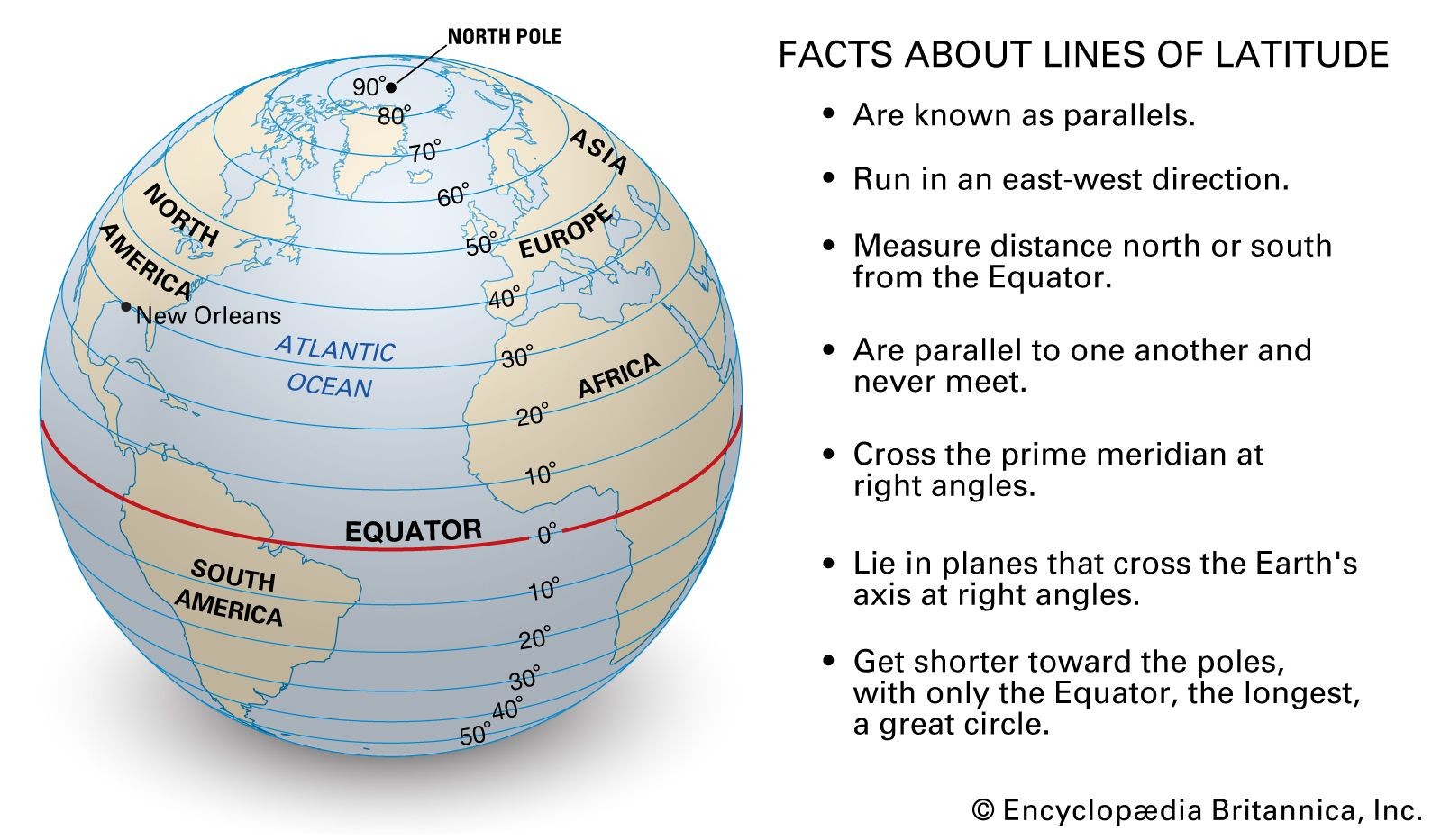
Latitude is the angular distance, usually measured in degrees, north or south from the Earth’s Equator. It is represented by imaginary lines encircling the Earth parallel to the Equator, known as parallels.
1.1. The Equator: The Starting Point
The Equator is the reference point for latitude, designated as 0 degrees. It is an imaginary line that divides the Earth into the Northern and Southern Hemispheres.
1.2. Parallels of Latitude
Parallels of latitude run east to west, parallel to the Equator. They are numbered from 0 degrees at the Equator to 90 degrees at the North Pole and 90 degrees at the South Pole.
1.3. Measuring Latitude
Latitude is measured in degrees (°), minutes (‘), and seconds (“). One degree of latitude is approximately 111 kilometers (69 miles).
1.4. Key Parallels of Latitude
- Equator (0°): Divides the Earth into the Northern and Southern Hemispheres.
- Tropic of Cancer (23.5° N): The northernmost latitude where the Sun can appear directly overhead at noon.
- Tropic of Capricorn (23.5° S): The southernmost latitude where the Sun can appear directly overhead at noon.
- Arctic Circle (66.5° N): The southernmost latitude in the Northern Hemisphere where the Sun can remain continuously above or below the horizon for 24 hours.
- Antarctic Circle (66.5° S): The northernmost latitude in the Southern Hemisphere where the Sun can remain continuously above or below the horizon for 24 hours.
- North Pole (90° N): The northernmost point on Earth.
- South Pole (90° S): The southernmost point on Earth.
1.5. Importance of Latitude
Latitude plays a crucial role in determining a region’s climate and weather patterns. Areas near the Equator receive more direct sunlight, resulting in warmer temperatures, while regions closer to the poles experience colder climates due to the angle at which sunlight reaches the surface.
2. Delving into Longitude: The East-West Measurement
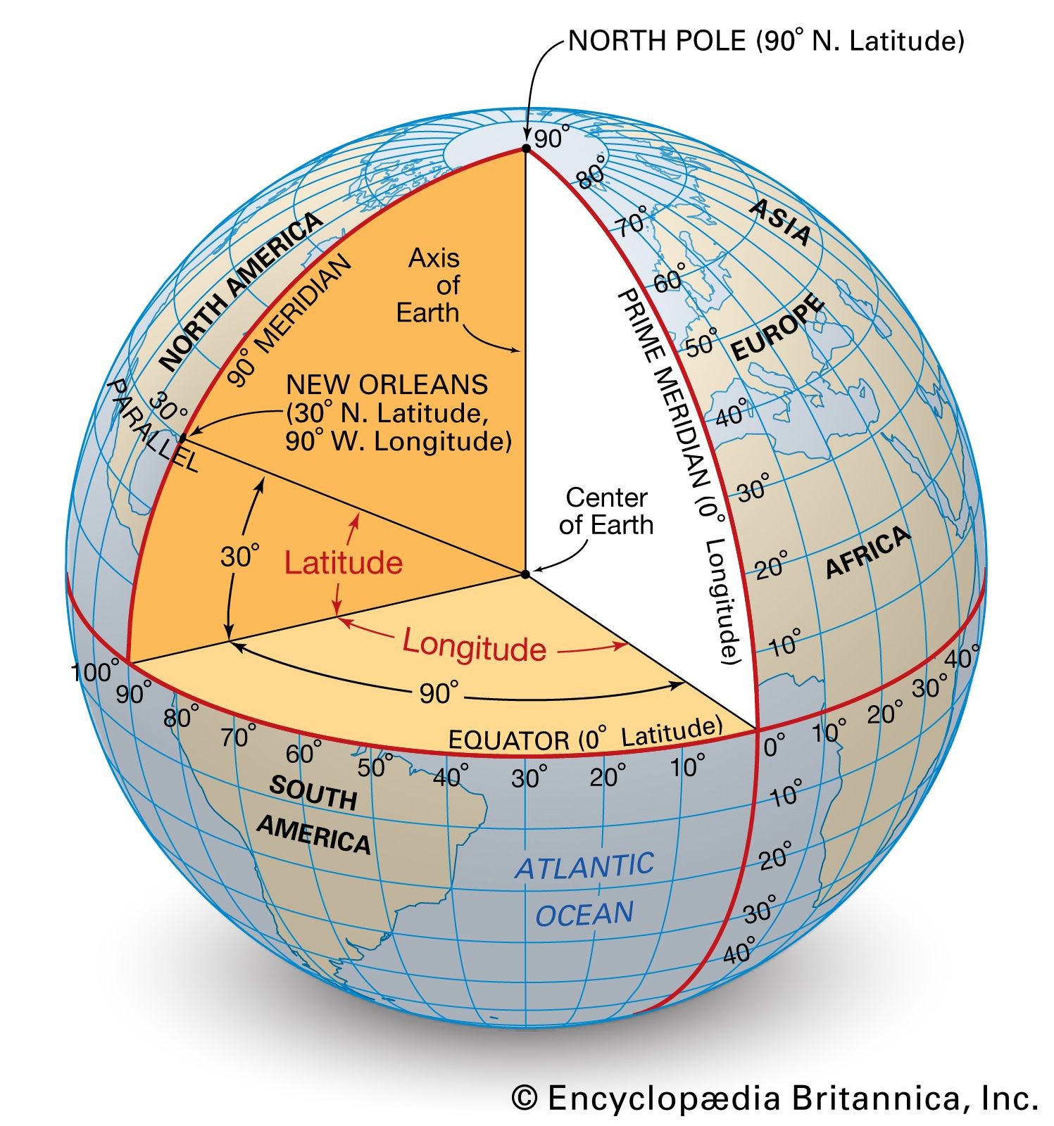
Longitude is the angular distance, usually measured in degrees, east or west of the Prime Meridian. It is represented by imaginary lines running from the North Pole to the South Pole, known as meridians.
2.1. The Prime Meridian: The Reference Line
The Prime Meridian is the reference point for longitude, designated as 0 degrees. It passes through Greenwich, London, England.
2.2. Meridians of Longitude
Meridians of longitude run north to south, converging at the North and South Poles. They are numbered from 0 degrees at the Prime Meridian to 180 degrees east and 180 degrees west.
2.3. Measuring Longitude
Longitude is measured in degrees (°), minutes (‘), and seconds (“). Unlike latitude, the distance of one degree of longitude varies depending on the latitude. It is widest at the Equator and narrows towards the poles.
2.4. The International Date Line
The International Date Line (IDL) is an imaginary line on the surface of the Earth that runs from the North Pole to the South Pole and demarcates the boundary between one calendar day and the next. It generally follows the 180° meridian, deviating in some places to avoid dividing land areas.
2.5. Significance of Longitude
Longitude is essential for determining time zones. The Earth is divided into 24 time zones, each approximately 15 degrees of longitude wide. As the Earth rotates, different meridians come into alignment with the Sun, resulting in varying times of day in different locations.
3. Latitude and Longitude Coordinates: Pinpointing Locations
Together, latitude and longitude coordinates provide a unique address for any point on Earth. Latitude is always given first, followed by longitude. For example, the coordinates for New York City are approximately 40.7128° N, 74.0060° W.
3.1. Decimal Degrees
Latitude and longitude can also be expressed in decimal degrees, which are often used in GPS systems and digital maps. To convert degrees, minutes, and seconds to decimal degrees, use the following formula:
Decimal Degrees = Degrees + (Minutes/60) + (Seconds/3600)3.2. Coordinate Systems
Various coordinate systems use latitude and longitude as their basis, including the World Geodetic System (WGS) 84, which is commonly used in GPS technology.
4. The Practical Applications of Latitude and Longitude
Latitude and longitude are vital in numerous fields, impacting navigation, mapping, climate studies, and more.
4.1. Navigation
Pilots and sailors rely on latitude and longitude for precise navigation, ensuring they stay on course and reach their destinations safely.
4.2. Mapping and Cartography
Cartographers use latitude and longitude to create accurate maps, representing the Earth’s surface and its features in detail.
4.3. Geographic Information Systems (GIS)
GIS professionals utilize latitude and longitude to analyze spatial data, understand geographic patterns, and make informed decisions.
4.4. Climate Studies
Climatologists use latitude and longitude to study climate variations, model climate change, and understand the distribution of weather patterns across the globe.
4.5. Surveying
Surveyors use latitude and longitude to establish property boundaries, construct infrastructure, and create accurate land surveys.
4.6. GPS Technology
Global Positioning System (GPS) technology relies heavily on latitude and longitude to determine the precise location of devices and vehicles. GPS devices use signals from satellites to calculate latitude, longitude, and altitude, enabling navigation, tracking, and location-based services.
5. Exploring Different Types of Latitude
While the term “latitude” is commonly used to refer to geographic latitude, there are different types of latitude, each with its specific application.
5.1. Geocentric Latitude
Geocentric latitude is the angle between the equatorial plane and a line from the point of interest to the Earth’s center. It is used in some scientific calculations but is less common in everyday use.
5.2. Astronomical Latitude
Astronomical latitude is determined by measuring the angle between the local zenith (the point directly overhead) and the celestial equator. It is used in astronomy and geodesy.
5.3. Geographic (Geodetic) Latitude
Geographic latitude, also known as geodetic latitude, is the angle between the equatorial plane and a line perpendicular to the Earth’s surface at the point of interest. This is the most commonly used type of latitude in mapping, navigation, and surveying.
6. Understanding the Relationship Between Latitude, Longitude, and Time Zones
The Earth is divided into 24 time zones, each roughly corresponding to 15 degrees of longitude. This division is based on the fact that the Earth rotates 360 degrees in 24 hours, so each 15-degree section experiences a one-hour difference in time.
6.1. Standard Time Zones
Standard time zones are based on the concept of Coordinated Universal Time (UTC), which is the primary time standard by which the world regulates clocks and time. Each time zone is offset from UTC by a specific number of hours.
6.2. Daylight Saving Time (DST)
Many countries observe Daylight Saving Time (DST), also known as summer time, during which clocks are advanced by one hour to make better use of daylight. This practice shifts the time zones, affecting the relationship between longitude and local time.
6.3. The Impact of Longitude on Time
The longitude of a location directly influences its time zone. Locations further east experience sunrise and sunset earlier than locations further west, leading to time differences that are essential for coordinating activities and schedules across different regions.
7. Common Misconceptions About Latitude and Longitude
There are several common misconceptions about latitude and longitude that can lead to confusion. Let’s address some of these:
7.1. Latitude and Longitude Lines are Visible on the Ground
This is a common misconception. Latitude and longitude lines are imaginary lines created for mapping and navigation purposes. They are not physical lines that can be seen on the Earth’s surface.
7.2. Lines of Longitude are Parallel
Unlike lines of latitude, lines of longitude are not parallel. They converge at the North and South Poles, meaning the distance between them decreases as you move away from the Equator.
7.3. Latitude and Longitude are Only Useful for Navigation
While latitude and longitude are crucial for navigation, they have many other applications, including mapping, GIS, climate studies, and surveying. They are fundamental tools for understanding and analyzing spatial data.
7.4. The Equator is the Only Important Line of Latitude
While the Equator is a significant line of latitude, other parallels such as the Tropics of Cancer and Capricorn, and the Arctic and Antarctic Circles, are also important for understanding climate zones and seasonal variations.
8. The Evolution of Latitude and Longitude Measurement
The methods for measuring latitude and longitude have evolved significantly over time, from ancient techniques to modern technologies.
8.1. Early Methods
In ancient times, latitude was often determined by measuring the angle of the sun or certain stars above the horizon. Longitude was more challenging to measure accurately, as it required knowing the time difference between two locations.
8.2. The Chronometer
The invention of the marine chronometer in the 18th century revolutionized longitude measurement. This accurate timekeeping device allowed navigators to determine longitude by comparing the time at their current location with the time at a known reference point.
8.3. Modern Technologies
Today, GPS technology provides highly accurate latitude and longitude measurements. GPS receivers use signals from satellites to calculate position with incredible precision, making navigation and mapping easier than ever before.
9. How to Find the Latitude and Longitude of a Location
There are several ways to find the latitude and longitude of a specific location.
9.1. Online Mapping Services
Online mapping services like Google Maps and Bing Maps allow you to search for a location and then right-click on the map to display the latitude and longitude coordinates.
9.2. GPS Devices
GPS devices, such as those found in smartphones and car navigation systems, can display the current latitude and longitude of your location.
9.3. Geographic Information Systems (GIS) Software
GIS software provides tools for analyzing spatial data and determining the latitude and longitude of specific points on a map.
9.4. Geocoding Services
Geocoding services convert addresses into latitude and longitude coordinates, allowing you to find the location of a specific address.
10. Advanced Concepts Related to Latitude and Longitude
Beyond the basics, there are several advanced concepts related to latitude and longitude that are important for professionals in fields like geography, surveying, and navigation.
10.1. Map Projections
Map projections are methods for representing the three-dimensional surface of the Earth on a two-dimensional map. Different map projections distort the Earth’s surface in different ways, affecting the accuracy of latitude and longitude measurements.
10.2. Geodesy
Geodesy is the science of accurately measuring and understanding the Earth’s geometric shape, orientation in space, and gravitational field. It involves precise measurements of latitude, longitude, and altitude, and is essential for creating accurate maps and navigation systems.
10.3. Datum
A datum is a reference point or surface against which position measurements are made. Different datums can result in slightly different latitude and longitude coordinates for the same location.
10.4. Coordinate Transformations
Coordinate transformations are used to convert latitude and longitude coordinates from one datum or coordinate system to another. This is important when working with data from different sources or when integrating data into a specific mapping system.
11. Fun Facts About Latitude and Longitude
Here are some interesting facts about latitude and longitude that you might not know:
11.1. The Equator is the Longest Line of Latitude
The Equator is the only line of latitude that is a great circle, meaning it divides the Earth into two equal halves. It is also the longest line of latitude, with a circumference of approximately 40,075 kilometers (24,901 miles).
11.2. The North and South Poles have No Longitude
Since lines of longitude converge at the North and South Poles, these points do not have a specific longitude. Any longitude can be used to describe a point at the North or South Pole.
11.3. The Prime Meridian was Not Always in Greenwich
The decision to locate the Prime Meridian in Greenwich was made in 1884 at the International Meridian Conference. Before this, different countries used different prime meridians, leading to confusion in navigation and mapping.
11.4. Latitude and Longitude Can Be Used to Create Art
Artists have used latitude and longitude coordinates to create unique artworks, such as mapping specific locations or creating geometric patterns based on coordinate systems.
12. The Future of Latitude and Longitude
As technology continues to advance, the future of latitude and longitude measurement and applications is bright.
12.1. Enhanced GPS Technology
Ongoing improvements to GPS technology are leading to even more accurate and reliable position measurements. This will benefit a wide range of applications, including autonomous vehicles, precision agriculture, and disaster response.
12.2. Improved Mapping and GIS
Advances in mapping and GIS technology are allowing for the creation of more detailed and accurate maps, as well as new ways to analyze and visualize spatial data.
12.3. Integration with Virtual and Augmented Reality
Latitude and longitude are being integrated into virtual and augmented reality applications, allowing users to experience virtual environments that are accurately geolocated in the real world.
12.4. New Applications in Scientific Research
Latitude and longitude are playing an increasingly important role in scientific research, including studies of climate change, biodiversity, and human migration patterns.
13. Frequently Asked Questions (FAQs) About Latitude and Longitude
To further clarify any remaining questions you may have about latitude and longitude, here are some frequently asked questions:
| Question | Answer |
|---|---|
| What is the difference between latitude and longitude? | Latitude measures the distance north or south of the Equator, while longitude measures the distance east or west of the Prime Meridian. |
| How are latitude and longitude measured? | Latitude and longitude are measured in degrees (°), minutes (‘), and seconds (“). |
| What is the Equator? | The Equator is the imaginary line that circles the Earth halfway between the North and South Poles, representing 0 degrees latitude. |
| What is the Prime Meridian? | The Prime Meridian is the imaginary line that runs from the North Pole to the South Pole through Greenwich, England, representing 0 degrees longitude. |
| How do I find the latitude and longitude of a place? | You can find the latitude and longitude of a place using online mapping services, GPS devices, or GIS software. |
| Why are latitude and longitude important? | Latitude and longitude are essential for navigation, mapping, climate studies, surveying, and many other applications. |
| What are the key parallels of latitude? | The key parallels of latitude include the Equator, Tropic of Cancer, Tropic of Capricorn, Arctic Circle, Antarctic Circle, North Pole, and South Pole. |
| How is longitude related to time zones? | The Earth is divided into 24 time zones, each approximately 15 degrees of longitude wide. As the Earth rotates, different meridians come into alignment with the Sun, resulting in varying times of day in different locations. |
| What are map projections? | Map projections are methods for representing the three-dimensional surface of the Earth on a two-dimensional map. Different map projections distort the Earth’s surface in different ways, affecting the accuracy of latitude and longitude measurements. |
| How has the measurement of latitude and longitude evolved? | The measurement of latitude and longitude has evolved from ancient techniques to modern technologies like GPS, leading to increasingly accurate and reliable position measurements. |
14. Real-World Examples of Latitude and Longitude in Action
To further illustrate the importance and practical applications of latitude and longitude, let’s explore some real-world examples:
14.1. Search and Rescue Operations
Search and rescue teams rely on latitude and longitude coordinates to locate individuals in distress. GPS devices and mapping systems allow rescuers to pinpoint the exact location of missing persons, even in remote areas.
14.2. Disaster Response
During natural disasters, such as earthquakes, hurricanes, and tsunamis, latitude and longitude are used to assess the impact of the event and coordinate relief efforts. Mapping systems help emergency responders identify affected areas and allocate resources effectively.
14.3. Precision Agriculture
Farmers use latitude and longitude to optimize crop yields and manage resources efficiently. GPS-guided tractors and drones collect data on soil conditions, plant health, and other factors, allowing farmers to make precise adjustments to irrigation, fertilization, and pest control.
14.4. Autonomous Vehicles
Self-driving cars rely on latitude and longitude to navigate roads and avoid obstacles. GPS and mapping systems provide the vehicle with real-time location information, allowing it to make informed decisions about steering, acceleration, and braking.
14.5. Climate Modeling
Climate scientists use latitude and longitude to model the Earth’s climate system and predict future climate change scenarios. Climate models divide the Earth’s surface into a grid of latitude and longitude points, allowing scientists to simulate the interactions between the atmosphere, oceans, and land.
15. The Role of WHAT.EDU.VN in Understanding Geographic Concepts
At WHAT.EDU.VN, we understand the importance of accessible and accurate information. We strive to provide clear explanations of complex topics like latitude and longitude, making them understandable for everyone.
15.1. Free Question and Answer Platform
We offer a free question and answer platform where you can ask any question about geography, science, or any other subject. Our community of experts and enthusiasts is ready to provide helpful and informative answers.
15.2. Comprehensive Educational Resources
Our website features a wealth of educational resources, including articles, tutorials, and videos, designed to help you learn about a wide range of topics.
15.3. Easy-to-Understand Explanations
We are committed to providing easy-to-understand explanations of complex concepts, ensuring that everyone can learn and grow.
15.4. Community-Driven Learning
Our community-driven learning environment encourages collaboration and knowledge sharing, making learning more engaging and effective.
16. Conclusion: Embracing the Power of Geographic Knowledge
Latitude and longitude are fundamental concepts that underpin our understanding of the world. From navigation to climate studies, these coordinates play a vital role in numerous fields, shaping our lives in countless ways.
By understanding what latitude and longitude are, how they are measured, and their various applications, we can gain a deeper appreciation for the interconnectedness of our planet and the importance of geographic knowledge.
At WHAT.EDU.VN, we invite you to explore the world of geography and beyond. Ask your questions, share your knowledge, and join our community of lifelong learners. Together, we can unlock the power of geographic knowledge and make a positive impact on the world.
Do you have more questions about latitude, longitude, or any other topic? Don’t hesitate to reach out to us at WHAT.EDU.VN. Our team of experts is ready to provide you with free, helpful answers. Contact us at 888 Question City Plaza, Seattle, WA 98101, United States. You can also reach us on WhatsApp at +1 (206) 555-7890 or visit our website at WHAT.EDU.VN. We’re here to help you explore the world and expand your knowledge.
17. Call to Action: Ask Your Questions on WHAT.EDU.VN Today
Are you curious about the world around you? Do you have questions about geography, science, history, or any other subject? Don’t keep your questions to yourself! Visit WHAT.EDU.VN today and ask our community of experts for free.
17.1. Get Answers from Knowledgeable Experts
Our platform connects you with knowledgeable experts who are passionate about sharing their knowledge. You’ll receive accurate and informative answers to your questions, helping you learn and grow.
17.2. Explore a Wide Range of Topics
Whether you’re interested in geography, science, history, or any other subject, you’ll find a wealth of information and resources on WHAT.EDU.VN. Explore our articles, tutorials, and videos to expand your knowledge.
17.3. Join a Community of Lifelong Learners
Our community-driven learning environment encourages collaboration and knowledge sharing. Connect with other learners, share your insights, and make new friends.
17.4. It’s Free and Easy to Use
Asking questions on WHAT.EDU.VN is completely free and easy to use. Simply create an account, post your question, and wait for our experts to provide you with helpful answers.
Don’t let your curiosity go unanswered. Visit WHAT.EDU.VN today and ask your questions. We’re here to help you explore the world and expand your knowledge. Our address is 888 Question City Plaza, Seattle, WA 98101, United States. Contact us on WhatsApp at +1 (206) 555-7890 or visit our website at what.edu.vn.